Over the last 20 years, GEER has established itself as the leading global organization for the investigation and collection of highly-valuable and perishable geotechnical insights and data and the timely distillation and provision of that information to the public through an exceptional body of reports.
GEER: Turning Disaster into Knowledge
Advancing hazard-resistant design demands that we understand what happened when a disaster occurs. Documenting and sharing the key lessons learned from extreme events around the world contributes significantly to advancing research and practice in hazards engineering. The importance of detailed mapping and surveying of damaged areas cannot be overemphasized, as it provides the data of well-documented case histories that drive the development of many of the design procedures used by geotechnical engineers.
Many engineering methods are based on insights gleaned from observations from past events. Field observations are particularly important in the discipline of geotechnical engineering, because it is difficult to replicate in the laboratory soil deposits built by nature over thousands of years. Further, much of the data generated by an extreme event is perishable and therefore must be collected within a few days of the occurrence of the earthquake.
Unfortunately, extreme events will happen. It would be even more unfortunate if the engineering profession did not capture the perishable data that enables us to understand which design procedures result in good seismic performance and which procedures still need improvement. With this understanding and with robust empirical data, earthquake professionals can advance the art and practice of geotechnical engineering.
A Brief History of GEER
The National Science Foundation (NSF) had historically supported geotechnical engineers and engineering geologists, who had self-assembled to conduct surveys of damage after large earthquakes. It recognized the value in having researchers witness the effects of earthquakes and collect perishable data. However, post-earthquake responses were often not well coordinated and photographs and notes taken by individuals were locked away in their offices and not shared. The late Dr. Cliff Astill of the NSF challenged geotechnical researchers to work together to improve the manner in which post-earthquake reconnaissance was conducted. In response to his challenge, the GEER Association was created.
GEER started as a grass roots collection of university professors and engineering practitioners who decided to combine efforts to perform post-earthquake surveys through event-focused NSF-sponsored grants that are now called RAPID awards. The documentation of the geotechnical effects of the 1999 Kocaeli, Turkey earthquake through the joint GEER-EERI reconnaissance effort described in Youd et al. (2000) is a great example of what could be accomplished. Soon afterwards, the NSF awarded GEER a grant to capitalize on recent technological developments and to formalize the manner in which NSF would sponsor post-earthquake geotechnical engineering reconnaissance efforts. Support of GEER continued with Dr. Richard Fragaszy of the NSF, who also recognized the critical role of post-event reconnaissance in advancing geotechnical research.
The goals of GEER are to advance the profession’s capabilities to conduct post-event reconnaissance and to interface more effectively with complementary in-country as well as other U.S. organizations. GEER employs enhanced techniques and systematic procedures to capture critical observations of the geotechnical effects of natural hazards and other extreme events.
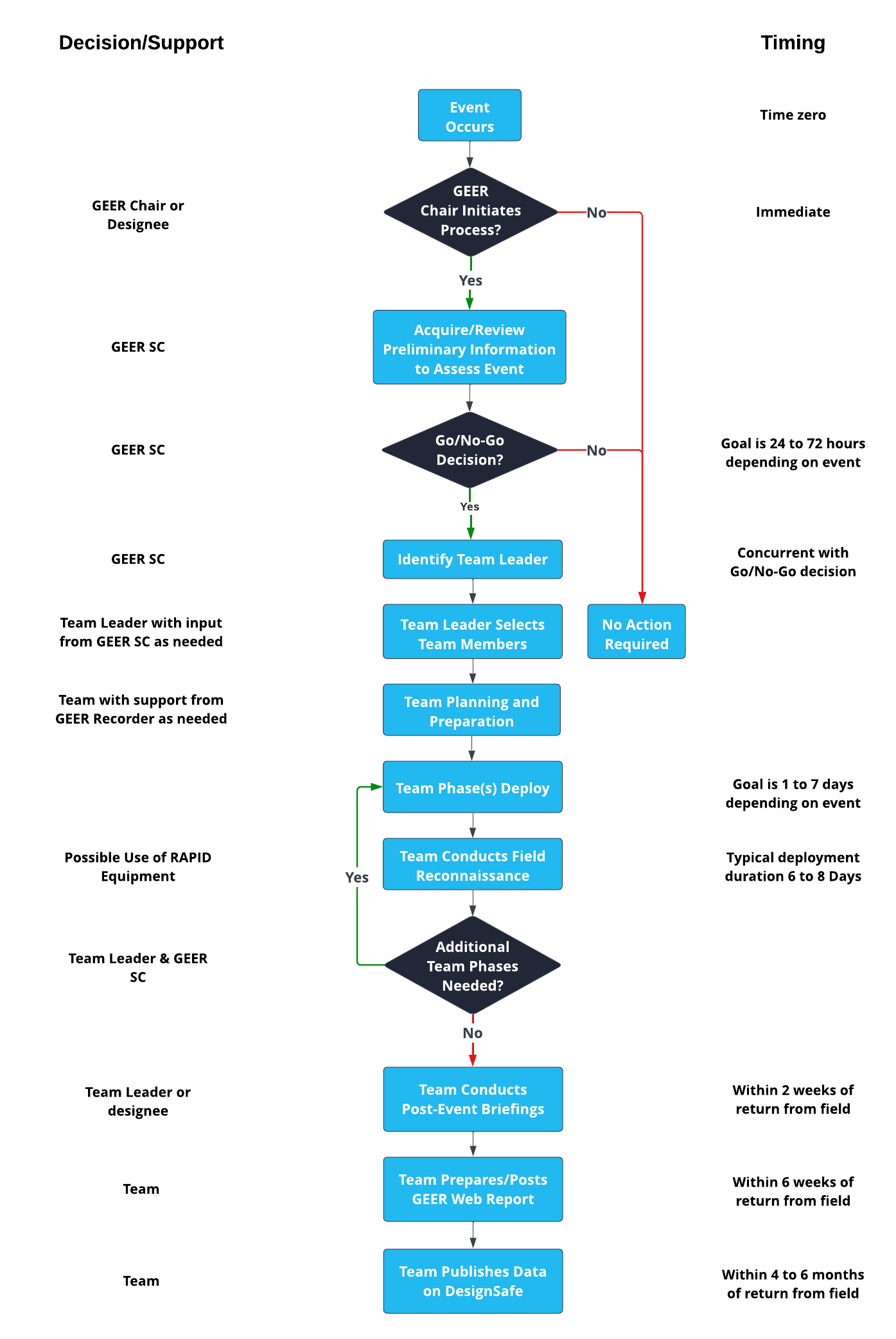
Many of the innovative techniques employed in recent post-earthquake reconnaissance efforts, such as the use of GPS (Global Positioning System) devices, Airborne and Terrestrial LIDAR (Light Detection and Ranging), satellite optical and SAR (Synthetic Aperture Radar) images, GoogleEarthTM, PDA (personal digital assistants) based software tools, and digital mapping tools, were developed by NSF-sponsored geotechnical engineers working as part of GEER survey teams. Those techniques that had proved successful in documenting quantitatively the effects of earthquakes could be applied with equal success to documenting the effects of other extreme events.
Recognizing its multi-hazards capabilities and the need to learn from other extreme events, GEER broadened its mandate to include all extreme events that provided opportunities to advance research and practice in geotechnical engineering. Its name was changed to Geotechnical Extreme Events Reconnaissance to reflect this broader mission. The ability of GEER to respond rapidly and access creative ideas of both experienced and younger geotechnical engineers is unmatched by any other organization.
The GEER Association is led by the GEER Steering Committee, which is a group of geo-engineers and scientists who have considerable post-event reconnaissance experience. The GEER Steering Committee receives guidance from a broad-based Advisory Panel. The GEER Advisory Panel is a larger group of prominent geotechnical engineers, hazard engineers and scientists in related fields, and personnel belonging to organizations that actively participate in post-event reconnaissance. The GEER Association currently has over 300 members who support the goals of GEER and participate in its activities. A cornerstone of NSF-sponsored GEER activities are web-based reconnaissance reports made available rapidly after the event.
GEER Mission Decision Process